

Skip to content
ITS Lab

Teaching

Thesis topics for bachelor's, master's and doctoral students, and the courses lab members teach at the Institute of Computer Science. To apply for a topic, write to its supervisor.

9 courses

Courses

6 courses

Current

27 topics

Thesis topics

12 topics

Open

  • A Learned Surrogate for Vehicle OD Calibration in Tartu’s Modal-Split SystemMaster's

    Amnir Hadachi, Artjom Lind · 2026

    Linked project. AI for Smart Automation

    Research question. Can a trained surrogate reduce the runtime of simulation-based vehicle OD calibration while retaining useful agreement with traffic counts and preserving plausible OD estimates?

    Approach. Generate training examples from candidate vehicle OD matrices and their simulated sensor counts. Train a model to approximate this OD-to-count relationship and use it inside the calibration procedure in place of repeated full simulations. Compare it with the published SUMO-based approach using the same network and sensor locations.

    Evaluation. Measure end-to-end calibration time, fit to held-out traffic counters, OD recovery where synthetic ground truth is known, and the effect of the resulting vehicle estimates on overall modal split. Test performance when sensor readings are missing. Report agreement with the existing estimator separately from accuracy against independent observations.

    Scope. Vehicle traffic in Tartu only; the bus, bicycle and pedestrian packages remain inputs to the existing framework.
  • Accuracy and Energy Cost of Traffic Forecasting at the EdgeBachelor's or master's

    Amnir Hadachi, Artjom Lind · 2026

    Linked project. AI for Smart Automation

    Research question. How much inference energy can a compact model save while maintaining useful accuracy when forecasting traffic counts on an edge device?

    Approach. Predict a measured traffic-count series at a fixed horizon, such as the next hour. Compare a historical or persistence baseline, a compact temporal model and a larger reference model. Test one compression technique, such as quantization, and run the models on the same device.

    Evaluation. Measure forecast error, inference latency, peak memory use and energy per prediction on the actual hardware. Report the accuracy–energy trade-off rather than assuming that a smaller model consumes less energy.

    Scope. Use one traffic dataset, one edge device and a small number of models. An MSc extension may compare forecasts across several sensors.

  • Auditable Evidence Records for Computational ExperimentsBachelor's

    Artjom Lind · 2026

    Research question. Can a structured experiment record help another researcher reconstruct and verify why a result was accepted?

    Approach. Develop a Git-based record format, a command-line validator, and a static view linking acceptance criteria, dependencies, configurations, results, and artifact hashes.

    Data. Completed laboratory experiments with their original logs and decisions, plus copies containing deliberately introduced errors.

    Evaluation. Error-detection rate, false alarms, and the accuracy and time required for independent readers to reconstruct decisions compared with the current notes.

    Manageable scope. One type of experiment and one repository; no scheduler, agent orchestration, or mobile client.

  • Can a Distilled Language Model Judge Driving Risk as Well as a Large One?Master's

    Helena Sokk, Artjom Lind · 2026

    Research question. Can a small language–vision model (distilled from a large VLM) predict and describe dangerous traffic situations from single video frames accurately enough to run in real time on vehicle hardware?

    Approach. Use a large VLM (e.g., GPT-4V-class or an open model like LLaVA) offline to generate structured risk descriptions and danger ratings for driving frames, with attention to pedestrian-crossing interactions. Distill these outputs into a compact student model (text-only or lightweight vision-language student), comparing distillation strategies: hard labels (risk class), soft scores, and natural-language rationales.

    Data. Pedestrian-crossing video datasets (JAAD, PIE, nuScenes) with teacher-generated annotations; a small human-verified subset for ground truth.

    Evaluation. Agreement with human and teacher risk ratings, calibration of risk scores, inference latency and memory footprint on edge hardware, and qualitative quality of generated situation descriptions.

  • Do Compressed Teacher Outputs Change Distillation Results?Bachelor's

    Artjom Lind · 2026

    Research question. Does storing only a teacher model’s top-k token probabilities change which student architecture appears to perform best?

    Approach. Compare k = 4, 8, 16 and methods for handling the remaining probability mass. Train two compact student architectures under matched conditions.

    Data. An approved subset of the existing top-16 teacher outputs and a small evaluation set with fuller teacher outputs.

    Evaluation. Held-out loss, calibration, stability of architecture rankings across random seeds, and storage and training cost.

    Manageable scope. Two architectures, one data subset, three values of k, and a fixed training budget.

  • Do Weather and Lighting Conditions Reveal When a Camera-Only Detector Will Fail?Bachelor's

    Helena Sokk, Artjom Lind · 2026

    Research question. Can image statistics (brightness, contrast, blur, rain streak density) predict which scenes an object detector will fail on, before deployment?

    Approach. Take a pre-trained detector and run it on driving footage grouped by conditions (day/night, rain/fog/clear). Compute simple image-quality proxies per frame, then test how well they predict per-frame detection failures, and whether a small confidence-correction model can flag unreliable predictions.

    Data. BDD100K or ACDC (adverse conditions), which come with weather/condition labels.

    Evaluation. Correlation between image statistics and detection errors, calibration of the failure-prediction model, and how often the flag catches the most dangerous misses (pedestrians, cyclists).

  • Evaluation of Existing Map-Matching Tools for Bicycle TrajectoriesMaster's

    Helen Tera · 2026

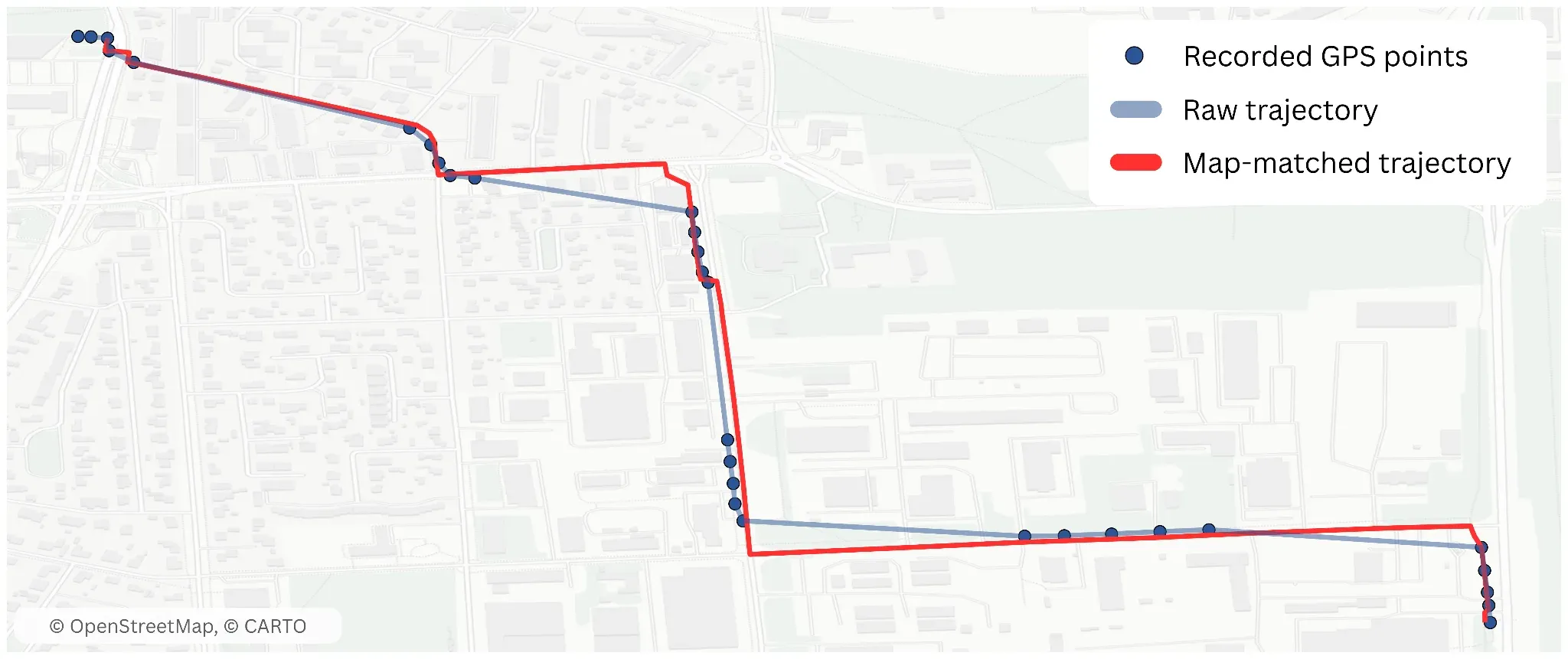
    Background. Map-matching is the process of aligning noisy geographic coordinates, such as raw GPS signals, with a representation of the street network. This is challenging in itself, but is especially tricky for cycling data, since cyclists constantly use different types of infrastructure and take shortcuts that are not represented in official network data.

    A bike trip in Tartu: recorded GPS points, the raw trajectory, and the map-matched trajectory

    Research questions. Which of the currently available map-matching tools perform best for cycling trips? How can we evaluate the correctness of the map-matching results?

    Approach. Compare 2–5 publicly available map-matching libraries. Identify, propose, and calculate metrics for evaluating the correctness of the resulting trajectories.

    Data. Tartu Smart Bike trip trajectories.

    Evaluation. Number of unmatched trajectories, difference in trajectory length, etc.

    Manageable scope. Comparison of at least two map-matching tools using quantitative metrics to evaluate and compare their performance.

  • Interpretable Discovery of Daily Mobility Routines from Trajectory SequencesBachelor's or master's

    Li Tetsmann, Amnir Hadachi · 2026

    Linked project. SMobility4ALL

    Research question. Can learned sequence representations identify stable and understandable routine types better than conventional mobility indicators?

    Approach. Compare clustering based on summary features, sequence distances, and compact learned embeddings.

    Data. Multiweek activity sequences; survey information can provide external validation.

    Evaluation. Cluster stability across weeks and resampling, representative daily patterns, and agreement with independently collected schedule information.

    Manageable scope. Cluster person-days, then summarize how an individual’s routine mix changes over time.

  • Propagating Missing-Data Uncertainty into Mobility IndicatorsBachelor's or master's

    Li Tetsmann, Amnir Hadachi · 2026

    Linked project. SMobility4ALL

    Research question. How much do missing GPS observations distort estimated travel distance, mode shares, and routine regularity?

    Approach. Compare a no-imputation baseline, simple interpolation, and one probabilistic sequence-imputation model. Produce multiple plausible reconstructions.

    Data. Relatively complete periods for controlled masking, alongside naturally incomplete records.

    Evaluation. Reconstruction error, interval coverage, and bias in downstream indicators under isolated gaps and extended outages.

    Manageable scope. One representation level, such as stays and trips, and two or three mobility indicators.

  • Reliable Data Fusion for Bicycle Modal-Split Estimation in TartuBachelor's

    Amnir Hadachi, Artjom Lind · 2026

    Linked project. AI for Smart Automation

    Research question. How do missing or inconsistent bicycle and pedestrian counter readings affect Tartu’s estimated cycling share, and which simple fallback method best limits the resulting error?

    Approach. Reproduce the bicycle package’s combination of bike-sharing trips and bridge sensor counts. Introduce controlled outages into periods with complete readings. Compare the current handling of missing data with simple alternatives, such as time-of-week estimates and estimates from other available counters.

    Evaluation. Measure reconstruction error at withheld counters and the change in estimated bicycle trips, district-level OD flows and cycling share. Separate agreement with the complete-data system output from validation against any independent counts.

    Scope. One transport mode and its existing input sources. The deliverable is a tested fallback method and an analysis of which missing sensors most strongly affect the result.

  • Transformers versus State-Space Models for Learning Daily Mobility RegularitiesBachelor's or master's

    Li Tetsmann, Jose Luis Medina Cartuche · 2026

    Research question. Under what history lengths and data conditions do transformers or Mamba-style models improve prediction of daily mobility routines?

    Approach. Represent mobility as sequences of visited places, arrival times, and durations. Compare a transformer and a state-space model against Markov, time-of-week, and GRU baselines.

    Data. Several weeks of repeated observations per participant.

    Evaluation. Next-place prediction, arrival-time error, performance on routine versus unusual days, training time, and memory use.

    Manageable scope. Predict the next visited place and its arrival time; test a small set of history lengths.

  • Trip-Chain Constraints and the Overestimation of Car-Substitution PotentialBachelor's or master's

    Li Tetsmann, Amnir Hadachi · 2026

    Linked project. SMobility4ALL

    Research question. How much does evaluating journeys independently overestimate the potential to replace car travel?

    Consider a day involving home → school → work → shopping → home. A feasible alternative for each individual leg may still fail to form a workable daily schedule.

    Approach. Reconstruct daily tours and compare independent-trip substitution with a constraint-based model of the complete tour.

    Data. Ordered trips, activity times, alternative routes, and available information about escorting, carrying requirements, or vehicle availability.

    Evaluation. Difference in replaceable trips and car distance, constraint violations, and sensitivity to uncertain activity-time flexibility.

    Manageable scope. One target mode and a small, explicitly defined set of constraints.

Taken

No topic is taken at the moment.

15 topics

Closed

Show
  • Hybrid Graph Neural Network and Agent-Based Modeling for Urban Traffic Flow Estimation Using Intersection Camera CountsMaster's

    Amnir Hadachi · 2025

    Accurate estimation of traffic flows is fundamental for intelligent transportation systems, urban mobility management, and sustainable planning. Traditionally, such estimations rely on extensive sensor infrastructures, including inductive loops, GPS trajectories, or mobile phone data. However, in many cities – particularly small and medium-sized ones – camera counts at intersections remain the most available and cost-effective data source. These counts provide only partial and noisy observations of the underlying traffic dynamics, making the problem of network-wide flow estimation challenging. Recent advances in Graph Neural Networks (GNNs) offer powerful tools for modeling spatiotemporal processes on road networks, learning flow patterns directly from graph-structured data. At the same time, agent-based models (ABMs), though computationally demanding, provide interpretable simulations that capture the microscopic decision-making of vehicles and drivers, such as route choice and turning movements. This project proposes a hybrid approach that integrates GNN learning with ABM insights to leverage the strengths of both paradigms.

  • Real-Time Temporal Dynamics Modeling with Large Language Models for Predicting Dangerous Situations in Urban Road ScenesMaster's

    Amnir Hadachi · 2025

    Autonomous vehicles (AVs) rely heavily on perception systems to ensure safe navigation in complex urban environments. While recent advances in multimodal large language models (MLLMs) have demonstrated strong capabilities in scene understanding, reasoning, and providing natural-language explanations, their application to real-time prediction of dangerous or risk-critical situations remains underexplored. Most existing approaches either (i) analyze static frames or short clips offline, (ii) generate risky scenarios for testing, or (iii) provide risk recognition without strict latency guarantees. However, urban driving demands continuous, low-latency anticipation of hazards – such as a pedestrian suddenly entering the road or a vehicle running a red light – where milliseconds of delay may determine safety outcomes. This thesis aims to close this gap by integrating temporal dynamics modeling into multimodal LLM frameworks, enabling predictive risk recognition in real time.

  • Spiking Neural Network Vs. Transformers in Object Detection in Urban Scenes: A Race for Energy EfficiencyMaster's

    Amnir Hadachi, Jose Luis Medina Cartuche · 2025

    Object detection in city environments is critical for applications such as autonomous driving, intelligent surveillance, and urban planning. As the complexity and scale of these applications grow, so does the demand for computational resources, leading to increased energy consumption. Traditional Transformer-based models, while powerful, are often energy-intensive. On the other hand, Spiking Neural Networks (SNNs), inspired by biological neural processes, promise significant energy savings due to their event-driven nature. This project explores the potential of SNNs as a more energy-efficient alternative to Transformers. The aim is to analyze the comparative performance of Spiking Neural Networks (SNNs) and Transformer-based architectures in object detection within urban scenes. The energy efficiency analysis focuses on determining which neural network paradigm offers superior performance from both (accuracy and liability) while minimizing power consumption. By leveraging neuromorphic hardware and optimizing Transformer models, the research seeks to contribute to developing sustainable and efficient AI systems for real-time urban environment analysis.

  • Station-level demand forecasting for Tartu Smart Bike using machine learningBachelor's

    Amnir Hadachi, Helen Tera · 2025

    Accurate forecasting allows operators to strategically reposition bikes, ensuring availability where and when it’s most needed. This directly contributes to a better user experience by reducing the frustration of finding empty docks or unavailable bikes. Furthermore, effective demand prediction is crucial for the equitable and sustainable expansion of bike-sharing systems, helping to mitigate urban congestion and promoting environmentally friendly transportation. What You’ll Build? Delve into the world of mobility modelling and machine learning to decide which is the best model for this task. Implement and validate a machine learning model to forecast demand in existing bikeshare stations using historic data and other information, such as weather and time of day.

  • Street-Level Proof-of-Location: Turning E-Scooters into Mobile Witnesses in an Urban MeshMaster's

    Amnir Hadachi, Eduardo Ribas Brito, Ulrich Norbisrath · 2025

    Location data is the backbone of today’s shared mobility services—but GPS alone is vulnerable to spoofing, tampering, and errors. How can we guarantee that an e-scooter was really at a parking bay, at the time a ride started or ended? This project transforms everyday e-scooters into mobile witnesses in a secure urban mesh. Using Raspberry Pi pods, UWB ranging, and BLE Direction Finding, scooters and curbside anchors will generate cryptographically verifiable proofs of location (PoL)—without touching scooter firmware. What You’ll Build? Rugged Raspberry Pi–powered PoL pods mounted on scooters, anchor stations with GNSS time sync and multi-antenna BLE/UWB arrays, a PoL protocol implementation with quorum attestations and transparency logging, and a live field pilot: ride start/end proofs, parking compliance, and anti-theft tracking. This is a hands-on thesis project: you will design hardware, implement secure protocols, and test your system on the streets. Perfect for those passionate about IoT security, smart mobility, and applied cryptography.

  • Enhanced sequence modeling using Mamba for Multi-Object TrackingMaster's

    Amnir Hadachi, Shan Wu · 2024

    Multi-object tracking (MOT) is a fundamental task in the field of computer vision that involves tracking multiple objects across video frames. It extends beyond simple object detection by maintaining consistent identities for each object throughout a sequence, despite challenges such as occlusion, abrupt movements, and changes in appearance. This capability is crucial for applications requiring detailed analysis of object interactions and movements over time. On the other hand, Mamba is a cutting-edge deep learning architecture designed for efficient sequence modeling, particularly addressing the limitations of traditional Transformer models in handling long sequences. This project aims to revolutionize multi-object tracking (MOT) by integrating the Mamba architecture as a long-sequence memory model. The goal is to enhance the ability of MOT systems to handle complex motion patterns and occlusions, which are common challenges in dynamic environments such as video surveillance and autonomous vehicles.

  • Estimating Energy Consumption of a Deep Learning ArchitectureMaster's

    Amnir Hadachi · 2024

    Deep neural networks (DNNs) have succeeded remarkably in various AI applications, including computer vision, speech recognition, and machine translation. However, their high computational demands result in significant energy consumption, which raises operating costs for data centers and limits their deployment on mobile devices with constrained energy budgets. As local processing on mobile devices gains popularity due to privacy, security, and latency concerns, designing energy-efficient DNNs becomes essential for advancing mobile AI applications. Hence, in this thesis, we will focus on designing a tool or technique for measuring the energy consumption of the DL model.

  • Interactive Web Dashboard for Tartu Smart Bike Data Visualization and AnalysisBachelor's or master's

    Helen Tera · 2024

    Tartu Smart Bike (Tartu rattaringlus) is a bike-sharing system in Tartu, providing residents with an affordable and environmentally friendly travel option. Over its five years of operation, it has accumulated a significant amount of data, including trip-level and detailed GPS data. This data can aid researchers and policymakers in designing more bikeable cities. While parts of this data have been utilized in various research projects, there is a lack of a comprehensive tool that would offer an overview of the data spanning the entire period of the system’s operation. The aim of this thesis is to create a web-based dashboard to visualize and explore Tartu Smart Bike data. The dashboard should enable users to examine bike-sharing usage from both spatial and temporal perspectives and compare different time periods. Depending on the scope, a more in-depth analysis of GPS trajectories could be included. The outcome of this work should be a web application that facilitates user-friendly exploration of the Tartu Smart Bike system.

  • Decision-Making for Mixed Traffic: Ramp-MergingMaster's

    Mozhgan Pourmoradnasseri · 2021

    Simulation and optimization of control strategies for ramp merging management.

  • Development of A Driving Cycle for Urban Buses in TartuMaster's

    Amnir Hadachi · 2021

    In order to evaluate the performance and feasibility of a new powertrain, driving cycles has been widely applied to represent real driving conditions. Since the driving behavior varies with the local conditions, typical driving cycles are needed considering local conditions, such as weather, terrain, and traffic status. Based on the GPS data, a typical driving cycle for buses in Tartu will be developed. This thesis topic is in collaboration with ITS Lab, Tartu City and OsloMet.

  • Feasibility Analysis and Optimal Charging Infrastructure Placement Strategy for City Bus System ElectrificationMaster's

    Amnir Hadachi · 2021

    Based on the GPS data of buses, the energy needed of each bus route under different weather can be derived. Therefore, the feasibility of different electric bus technologies should be analyzed. Considering the bus schedule and route-level energy consumption, optimal charging infrastructure placement and charging strategies should be developed considering battery life and lifecycle cost. This thesis topic is in collaboration with ITS Lab, Tartu City and OsloMet.

  • Has COVID-19 Changed Bike Usage Patterns of Tartu City Bikes?Bachelor's

    Mozhgan Pourmoradnasseri · 2021

  • Modal SplitMaster's

    Kaveh Khoshkhah · 2021

    Discovering the share of different means of transport is an important component for developing sustainable transport system. In this thesis, the initial modal split model will be created using some stochastic data. Then, using online data (such as traffic count), the model will be calibrated on short time intervals. This thesis topic is in collaboration with ITS Lab and Tartu City.

  • State-Full Masking of Dynamic Objects for Visual Simultaneous Localization and MappingMaster's

    Artjom Lind · 2021

    Advancing in the direction of reducing the time complexity of masking the moving objects Visual SLAM input. It was proven in previous research MaskRCNN is accurate but can hardly achieve 10FPS. Objective is to employ state estimation techniques to track the moving objects and update the masking information faster then actual detection rate.

  • SUMO Simulator: Add Support for Concurrent ExecutionMaster's

    Artjom Lind, Amnir Hadachi · 2021

    Simulator of Urban Mobility (SUMO) is an open source, highly portable, microscopic and continuous multi-modal traffic simulation package designed to handle large networks. Current implementation performs all the road network related routines (simulation, calibration etc.) using single thread hence under-utilizing the multi-core CPU. The objective is to achieve better CPU utilization by allowing multiple concurrent threads within one simulation.

2 projects

Education projects